
Know Before You Go: Tips For Hiking Kanarra Falls
Recently, Kanarra Falls has gained notoriety as a favorite destination for adventure seekers. Hidden falls nestled among red rock walls, what’s not to love? While this hike is considered an easy canyoneering experience – because special gear or equipment is not required – it is still a challenging hike. The trail leads through water, so you will get wet, and climbing the two waterfalls requires a bit of sure-footedness. When you reach the first set of falls you’ll have to trust handmade wooden ladders, ropes bolted to the canyon, and other peoples’ slings, making this a true ‘hike at your own risk’ experience.
So, before deciding to hit the trail and go, here are a few tips and things to know for hiking Kanarra Falls.
For more information, ticket reservations, and weather conditions visit kanarrafalls.com call (435) 590-7490 or email manager@kanarrafalls.com.
For information about staying safe in the backcountry visit secure.utah.gov/rescue/
Be Prepared & Hike at Your Own Risk:
#1 NOT RECOMMENDED FOR CHILDREN UNDER 8
Kanarraville Falls is considered a family-friendly canyoneering excursion because it doesn’t require special climbing equipment. However, it can be challenging for younger children and is not recommended for anyone with physical limitations. Be aware that there are obstacles to climb over, slippery/uneven surfaces, and unstable ladders to traverse.
#2 THERE IS A REAL DANGER OF FLASH FLOODING
Kanarra Creek is a slot canyon and there is a very real danger from flash flooding. Flash floods can occur at any time of year but are most common in July, August, and September. Check the local forecast and remember conditions change quickly; call the National Weather Service at (801) 524-3057.
Know your escape routes, be aware of rising water levels, stronger currents, and sudden changes in water clarity. By entering a narrow canyon or wash, you are assuming a risk.
Do not hike this trail if it is raining or if there is a threat of heavy rain.
#3 KANARRA FALLS HAS LIMITED FACILITIES
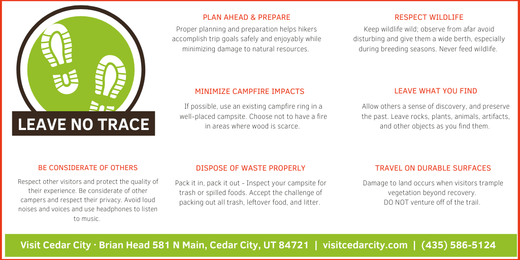
There is only one restroom at the beginning of the Kanarraville Falls trail, as well as one which is located at the parking lot. Please follow Leave No Trace principles and pack out human waste or bury in “cat holes” dug 6-8 inches deep at least 200 feet from water, trails, and drainages. Bring a trowel to dig the hole, and disguise it well after use. If possible, pack out used toilet paper. Otherwise, use as little as necessary then bury it deep in the hole.
#4 ABSOLUTELY NO PETS!
Leave pets at home – Kanarra Creek is the water supply for Kanarraville town. Human and animal feces and urine can cause contamination.
#5 UTAH SEARCH & RESCUE ASSISTANCE CARD (USARA)
Backcountry rescue can be very costly. The USARA card provides you and your family peace of mind and helps support vital search and rescue services. Learn more at secure.utah.gov/rescue.
Finding the Trail & Getting your Permits:
As of 2019, a permit is required to hike Kanarra Falls. The Kanarraville Town Board voted on some changes to Kanarra Falls for 2024. The age limit was raised to 7 yrs and under are free and the permit limit was also raised to 200 permits issued per day, purchasing your permit ahead of time is recommended. You can check availability and purchase your permits online at www.kanarrafalls.com or at the trailhead. Permits are $15 per person and only credit or debit cards are accepted. Also so new in 2024 a special use permit for all commercial groups will be required.
The Kanarra Falls trailhead is located about 20 minutes south of Cedar City in Kanarraville, Utah. Turn east at 100 North and travel a few blocks towards the water tank. Park in the designated parking lot. Do not park in front of homes or driveways.
About the Trail:
From the Kanarra Falls parking lot, head through the hiker’s gate and follow the old access road (approximately 0.8 miles) as it wanders up into the Hurricane Cliffs and enters the lower open sections of the canyon. The trail will cross the stream several times along the road. The road ends by the water well and the trail continues in the stream most of the time. (We highly recommend good water hiking shoes.)
At this point, the trail is mostly overgrown and you will be alternating between hiking in the (usually less than a foot-deep) water and hiking on one of the many short trails on both sides of the stream. Whatever route you choose, please do your best to avoid causing any more erosion to the banks. After about half a mile, the canyon slots up and continues to the first major landmark of the hike: Kanarraville Falls, a 15-foot high rock-jam waterfall.
The first waterfall (approximately 1.5 miles) presents a 20′ aluminum ladder. Scaling this ladder is required to continue the hike. The ladder may be icy, wet, and slippery. HIKE AT YOUR OWN RISK. Some hikers opt to turn around at this point; arriving at the first waterfall is awe-inspiring, and the moments and memories won’t soon be forgotten.
If you continue hiking, the canyon opens up to a natural waterslide and flat rocks that make a perfect snack spot (approximately 2 miles). After a snack, be sure to inspect your surroundings for trash or spilled foods. Accept the challenge of packing out all trash, leftover food, and litter.
A bit further up the trail, hikers come to deeper water with the narrowing slot section of the second waterfall (approximately 2.5 miles). Do not use makeshift rope or log ladders, these are not maintained and are dangerous. DO NOT GO BEYOND THIS POINT. It is extremely difficult for Search and Rescue to reach this area.
4 Alternatives to Kanarra Falls:
If Kanarra Falls doesn’t feel like the right fit for your adventure, check out these nearby hikes as great alternatives.
LICHEN IT, CEDAR CITY
The trail meanders back and forth across the face of Cedar City’s foothills as it climbs the west-facing slope. The trail is open to mountain bikers.
CASCADE FALLS, DIXIE NATIONAL FOREST
Didn’t pack your water shoes? Check out the Cascade Falls trail in Dixie National Forest for another amazing waterfall with a view of Zion National Park.
TIMBER CREEK, KOLOB CANYONS
For a short walk with views of Kolob Terrace and the Pine Valley Mountains, hike the Timber Creek Overlook Trail at the end of Kolob Canyons Road.
HIDDEN HAVEN, DIXIE NATIONAL FOREST
Located in beautiful Parowan Canyon, Hidden Haven Trail leads through a wildlife study area, traverses a granite rockfall, and ends at a 20-foot waterfall.
For more information on this trail and others located near Cedar City, check out our hiking trails page.
*Hike at your own risk. This is a reference guide only and Visit Cedar City • Brian Head Tourism Bureau assumes no responsibility for errors, omissions, or changes.